

|
|
|
Ground-Level Ozone Maps Residents in most of Eastern Canada can see near real-time readings of ground-level ozone in their areas on the new AIRNOW Internet site. Initiated by the New England Governors/Eastern Canadian Premiers (NEG/ECP), AIRNOW is a cooperative venture involving the provinces and states of the NEG/ECP, Environment Canada, the United States Environmental Protection Agency (EPA), and the New England States Environment Agencies.
To avoid breathing heavy smog, many health experts recommend that the elderly, children and people with pulmonary problems take it easy and stay indoors when ozone levels are high. The AIRNOW Internet site provides hourly information on ozone concentrations in Ontario, Quebec, New Brunswick, Nova Scotia, Prince Edward Island, and the New England states.The Canadian site features two maps of Eastern Canada—one showing hourly values, and the other peak values. Ozone levels are represented as coloured areas on the maps, with each colour representing a different ozone concentration ranging from zero to 120+ parts per billion (ppb). The Canadian Air Quality Objective for ozone is 82 ppb over one hour. Levels above this value pose an increasingly greater risk of respiratory effects. Readings are updated hourly, from 7 a.m. to 7 p.m., seven days a week. Canadian data is submitted by participating provinces to Environment Canada’s Meteorological Service of Canada. There it is collated and transferred to the EPA in South Carolina, where a supercomputer creates the merged maps. Organizers hope to add information on ozone levels in other provinces. If you are interested in obtaining information about air quality programs in your region, please visit the Air Quality Program page now available on Environment Canada`s Clean Air Web Site.
|
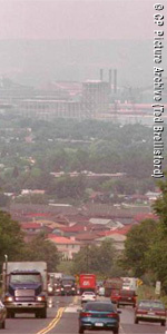 Ozone,
which is smog`s main ingredient, is an air pollutant that can irritate
the lungs and make breathing dangerously difficult for people with
asthma or other lung ailments. Most ozone at ground level is formed
as urban air pollutants mix together on hot summer days.
Ozone,
which is smog`s main ingredient, is an air pollutant that can irritate
the lungs and make breathing dangerously difficult for people with
asthma or other lung ailments. Most ozone at ground level is formed
as urban air pollutants mix together on hot summer days.